
www.industry-australia.com
10
'26
Written on Modified on
Leica Geosystems introduces Leica DMC-5 large-format camera
Capturing over 30% more data than previous generations, the new system increases coverage and gives operators the flexibility to adapt to a wide range of mapping requirements.
leica-geosystems.com
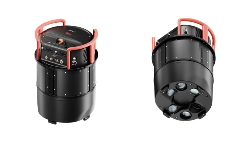
Aerial photogrammetry and large-scale spatial mapping campaigns face persistent economic and operational constraints linked to aircraft flight hours, airspace availability, and weather windows. High-altitude photogrammetric survey operations must balance broad ground coverage with fine ground sampling distance (GSD) to satisfy national mapping standards, cadastre maintenance, and urban infrastructure planning. Historically, increasing ground coverage required operators to fly at higher altitudes or operate multi-head oblique systems, both of which introduce geometric distortion, complex camera calibration drift, and significant radiometric variation across wide viewing angles. Alternatively, flying narrower swaths forces flight crews to run tighter flight-line spacing, driving up fuel burn, airframe maintenance costs, and flight-crew fatigue. Furthermore, high-speed turboprop aircraft frequently induce motion blur during low-altitude or high-velocity capture, degrading edge definition in stereo photogrammetry and digital elevation model (DEM) extraction. Addressing these survey efficiency bottlenecks requires scalable, large-format nadir imaging architectures that combine wide cross-track pixel footprints with active angular stabilization and true mechanical motion compensation.
Configurable Modular Architecture and Wide-Angle Swath Flexibility
To increase aerial survey productivity, Leica Geosystems, part of Hexagon, announced the Leica DMC-5 next-generation airborne imaging system. Built around the proprietary Leica MFC250 camera core within an adaptable sensor architecture, the DMC-5 enables survey operators to balance image footprint and ground resolution against specific mission parameters and regulatory airspace restrictions.
The camera platform introduces two selectable operational tiers, scaling up to an across-track resolution of 68,800 pixels. This expanded sensor footprint captures more than 30 percent more data per flight pass compared to previous camera generations, allowing flight planners to broaden flight-line spacing and reduce total flight hours per survey block. The platform provides flexible field-of-view profiles: the standard configuration covers angular spans from 36 degrees to 63 degrees, while the high-productivity X configuration expands the field of view up to 71 degrees. This angular range allows operators to capture high-density nadir imagery in restricted airspace corridors or execute wide-swath regional orthophoto campaigns from higher cruising altitudes while preserving frame-based outputs for downstream photogrammetric triangulation.
Mechanical Motion Compensation and Integrated Processing Pipeline
To maintain radiometric fidelity and sub-pixel edge sharpness at elevated transit velocities, the DMC-5 incorporates Leica Geosystems’ mechanical forward-motion compensation (FMC). Rather than relying purely on electronic sensor shifting or post-capture deconvolution software, the mechanical FMC system physically synchronizes the focal plane movement with aircraft ground speed during exposure, eliminating forward image smear.
The camera core is mounted inside the Leica PAV gyro-stabilized platform, which actively isolates the optical assembly from angular aircraft disturbances—pitch, roll, and yaw drift—ensuring vertical optical alignment through turbulent atmospheric layers. Mission data integrates directly into the Leica HxMap unified multisensor workflow platform. Within HxMap, raw sensor packets undergo automated data ingestion, radiometric leveling, atmospheric correction, and bundle block adjustment, allowing survey organizations to produce seam-free digital orthomosaics, point clouds, and textured 3D meshes within a single unified processing pipeline.
Additional Context
This section details technical specifications and competitive benchmarking not included in the original product announcement.
In aerial metric camera design and spatial surveying governed by standards such as ASPRS (American Society for Photogrammetry and Remote Sensing) Positional Accuracy Standards for Digital Geospatial Data, maintaining geometric integrity across large-format sensors requires rigid optical bench alignment and stable interior orientation parameters. Metric frame cameras differ from line-scanner pushbroom systems by capturing distinct frame perspectives that retain standard central perspective geometry, which is essential for stereoscopic feature extraction, aerotriangulation, and vertical height determination. When aircraft operate at high speeds relative to altitude, exposure duration creates optical forward shift that can blur high-contrast ground targets. While time-delayed integration (TDI) or digital FMC software attempts to counteract smear by shifting charge across CCD/CMOS rows or applying deblurring convolution kernels, these digital methods often introduce noise artifacts or limit dynamic range. Mechanical FMC physically moves the sensor array along the flight axis via precision linear voice-coil actuators during the millisecond shutter window, preserving optical Modulation Transfer Function (MTF) sharpness and dynamic range across low-illumination morning and late-afternoon flights.
Within the large-format commercial airborne photogrammetric camera sector, the Leica DMC-5 benchmarks directly against high-end nadir and hybrid frame platforms, primarily the Vexcel Imaging UltraCam series (including the UltraCam Eagle M3 and UltraCam Osprey 4.1) and Phase One aerial systems (such as the PAS 880 and 280MP large-format systems), as well as earlier DMC iterations like the Leica DMC III. While Vexcel’s UltraCam Eagle uses synthetic pan-sharpening architectures to stitch multiple optical cones into a synthetic panchromatic frame exceeding 450 megapixels with proprietary electronic motion compensation, the DMC-5 emphasizes a modular mechanical sensor platform with native frame geometry and a swath width reaching 68,800 pixels across-track. Furthermore, unlike standalone aerial camera heads that require third-party positioning systems and separate post-processing software suites, the DMC-5 is architecturally coupled with Hexagon’s NovAtel GNSS/IMU positioning units, PAV gyro-stabilization, and the HxMap production suite. This end-to-end integration allows national geospatial agencies and commercial survey firms to deploy the camera across varied twin-engine turboprops without needing custom software bridges between sensor capture, georeferencing, and orthorectification.
Edited by Romila DSilva, Induportals Editor, with AI assistance.
www.leica-geosystems.com
